Radar
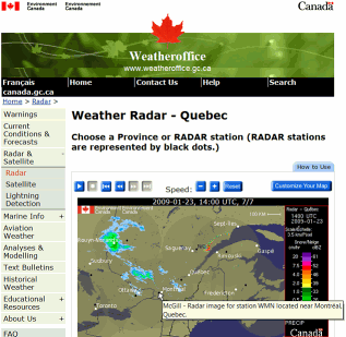
If you have looked for weather information on the web, you have come across web pages like the one on the left showing radar imagery of precipitation. In fact, radar is used regularly in meteorology for weather surveillance, or the real-time monitoring of the current situation and and of its evolution. As a result, there are over 200 radars in North America alone used for that task.
Radar is one of the rare instruments that can obtain weather-related information in three dimensions (x,y,z) as a function of time. It can see inside storms, and can be used to assess storm severity using the reflectivity information as well as Doppler velocity information (what are the winds within the storm). It provides unique information such as precipitation intensity, radial winds, particle type (using dual-polarization). As an active remote sensor, it does not suffer from many of the observation problems associated with passive sensors, such as image displacement, changing illumination, or limited ranging ability. Most importantly, this information is available immediately, and can therefore be immediately used. And we can use its data to make good forecasts at short range (0-6 hr). Meteorologists love their radar. And our group specializes in making radar even more useful.
VertiX
Example: Vertically pointing X-band radar (VertiX) VertiX is a simple radar that looks directly upwards. Its measurements are displayed as time-height sections of reflectivity and Doppler velocity of weather as it passes overhead. It has little uses for forecasting (by the time you see weather, it is on top of you!), but its great spatial and temporal resolution makes it very useful for research.
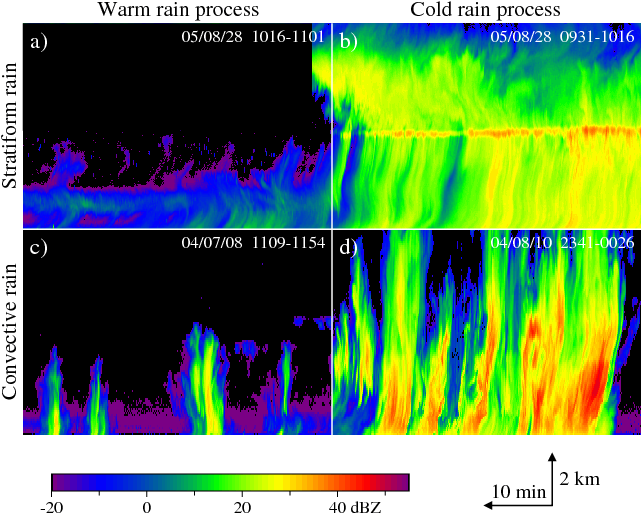
As illustrated in the figure below, considerable variety in the type of rain echoes can be observed:
-
Low level rain or drizzle extending a couple of kilometers in height at most;
-
Extended rain that starts as snow from an altitude of 6 to 9 km with a bright band;
-
Small showers, generally extending to the 0°C level and not further up;
-
Deep convection, intense thunderstorms reaching altitudes in excess of 10 km.
Even within these "classes" of echoes, considerable variability can be observed.

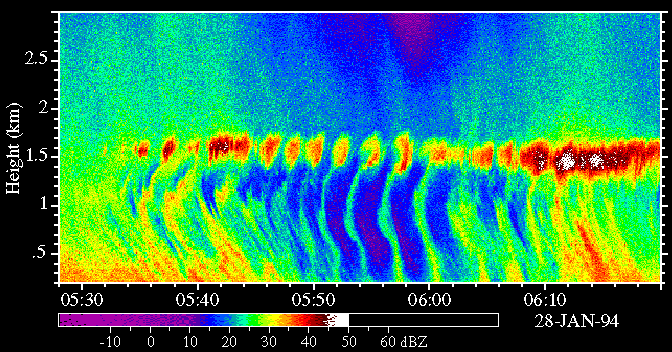
Some of the most spectacular (and puzzling) VPR images are related to the change of precipitation phase between snow and rain. In this particularly complex case (below), precipitation at the surface was snow at the beginning, turning to freezing rain afterward. The transition between the two showed some interesting oscillations back and forth between snow (when there is no "bright band" at 1.6 km) and freezing rain. These oscillations are likely related to "gravity" waves riding on the warm front gradually descending with time

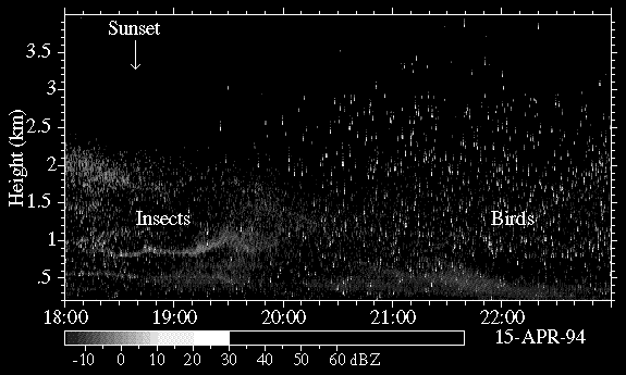
Radars are not selective about targets. As a result, we can also observe a lot of non-weather targets. These include airplanes at random intervals (very strong targets), insects (particularly during summer days), and birds (especially spectacular at night during migrations). The various echoes can be easily distinguished because they have very different characteristics: rain and clouds are large "cloud-like" echoes often with streaks going down; insects are also "cloud-like", but generally form thin layers (see left of image) and are always found at low levels; birds (like airplanes) look like "hard" point targets (right of image).
 {.center}
Since we have added Doppler capability to the vertically pointing radar, we have gained some sensitivity and are able to measure the fall speed of targets. This has open a new wealth of possibilities including better target identification (rain, snow, drizzle, etc. all fall at distinct and different speeds) and observations of new kinds of targets. In this example, with reflectivity in the top image and vertical velocity (up when positive) in the bottom image, we can observe two kinds of targets. From the ground to 2 km, we can see a mass of insects going up and down with the turbulence associated with the lowest layer of the atmosphere. Around 3 km, we see cumulus clouds in which vertical velocities up to 8 m/s (30 km/hr) are observed around 10:38. In the second important cloud (11:15), a few raindrops have been produced and are falling at 6 m/s to 8 m/s.